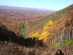
This picture was taken on November 6, 2008 on the mountain ridge of Bull Mountain. At the fire tower the elevation is 3193 feet.
The Bull Mt. fire tower is on the NATIONAL HISTORIC LOOKOUT REGISTER.
Elevation: 3193'
Coordinates: N36.69285 W80.224729
Administrative Unit: Virginia Department of Forestry
Cooperators: Virginia Department of Forestry
Date Registered: 12/30/1994
Reference: http://www.firelookout.net/
Picture taken by Tom Bishop, Executive Director, Patrick County Chamber of Commerce
276-694-6012
www.patrickchamber.com
patcchamber@embarqmail.com
